

Long before Mackinac Island became a popular summer travel spot with historic hotels, world-famous fudge and charming horse-drawn carriage rides, it was a military stronghold. But long before even Fort Mackinac was established, it was the unbridled power of the surrounding water itself that made Mackinac Island into what it is today.
In fact, Mackinac Island’s most popular natural attractions were here eons ago.
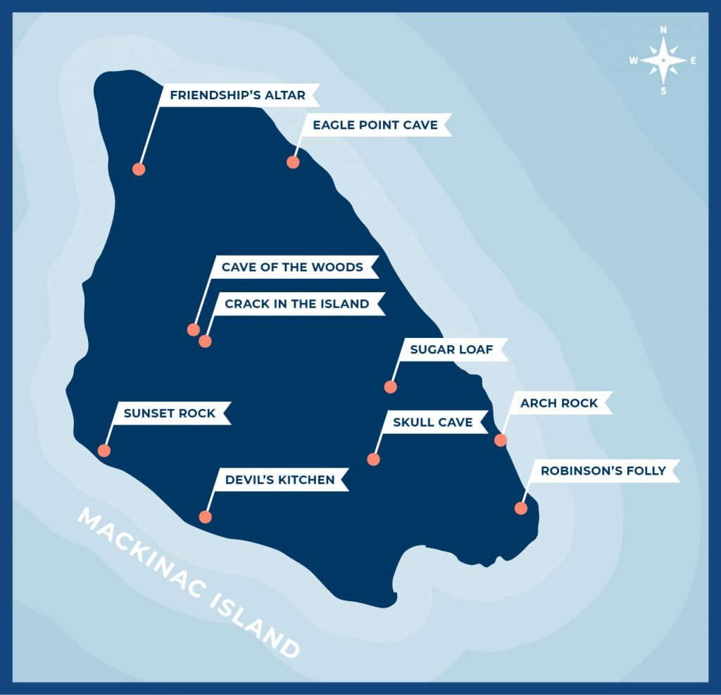
Mackinac Island’s Iconic Rock Formations
The picturesque Arch Rock, for example, is a natural limestone arch that today stands nearly 150 feet above Lake Huron. Some 7,500 years ago during a period of high water, Arch Rock was at water level. And it probably wasn’t even an arch at that point. The popular spot for sightseers likely was created by waves smashing into the island, again and again, eroding softer parts of the shore and hollowing out the center of the arch. The limestone that remained created a killer Mackinac Island selfie spot!
Ditto for Sugar Loaf, the 75-foot high limestone stack in the middle of Mackinac Island. The natural feature that’s a destination for hikers and bikers probably dates even farther back – more than 10,000 years! It was formed when the waters of ancient Lake Algonquin receded and wore away surrounding rocks and soil.
Not all of Mackinac Island’s geologic features are still visible today. For one, the 100-foot high Mackinac Falls that connected Lakes Michigan and Huron thousands of years ago now sits submerged under about 110 feet of water about a mile east of Arch Rock.
The story of Lover’s Leap and other natural wonders on Mackinac Island

Friendship’s Altar on Mackinac Island
One ancient geologic feature on Mackinac Island that does remain visible – yet still goes largely undiscovered by visitors – is Friendship’s Altar. Like Arch Rock and Sugar Loaf, Friendship’s Altar is a stack of limestone rising out of the earth.
Several thousand years ago, as the surrounding high water gradually retreated to its current level, much of the land around Friendship’s Altar was washed away. But because the limestone was strong enough to withstand the waves as the lake level diminished, the chunk of rock now known as Friendship’s Altar remains.
At 13 feet high and eight feet wide, Friendship’s Altar is much smaller than Sugar Loaf. Yet it’s plenty large enough to be found by hikers who step off the beaten path around Mackinac Island and venture into the wooded interior.
Friendship’s Altar is just east of British Landing near the northern tip of Mackinac Island, about halfway around the 8.2-mile loop that circles the outer rim of the island. You can get to Friendship’s Altar by taking the British Landing Nature Trail.
Right near Friendship’s Altar is a wooden overlook that you can climb to get a look above the Mackinac Island tree canopy. From up there you can see St. Ignace across the water on the mainland of Michigan’s Upper Peninsula.
RELATED MACKINAC ISLAND BLOGS:
